Showing posts with label Capertee Valley. Show all posts

Wednesday, 2 March 2016

Artist Profile: Leonard Long

There are few people who can claim to know the Capertee Valley so well over such a long time. One such person is the landscape artist Leonard Long who was born well over a century ago in 1911. Although never a local resident Long has visited the Capertee Valley many times to paint during his long art career.

Morning Light, Glen Davis, oil by Leonard Long
image courtesy ASSD website

Long first painted in the valley in the late 1940s and his first images from the area were exhibited at the 1949 annual show of the Royal Art Society in Sydney, and he has painted in the area several times since. 

The Lone Gum, Glen Davis
miniture oil by Leonard Long

image courtesy Davidson Auctions
The son of a baker, he was born in Summer Hill, Sydney on 25th April 1911, but was raised in the Southern Highlands of NSW where he showed an early aptitude for art. Despite his artistic talent he later became a watchmaker and moved to Nowra in the Shoalhaven. In 1955 he sold his watch-making business and became a full time painter. In 1980 he moved to Melbourne where he now lives. In 2011 he held a centenary exhibition of his work, a rare achievement for any artist.

Leonard Long AOM, circa 1984
Photo of Leonard Long
image courtesy Wikipedia
Leonard Long has painted all over Australia and elsewhere in the world. A career highlight was when he painted with the Aboriginal landscape painter Albert Namatjira. Long is part of the outdoor painting tradition which his often called en plein air painting, an artistic technique where images are created outdoors in front of the scene rather than making images in studios from preliminary drawings or photographs.

On behalf of the people of Capertee we wish Mr Long well in the final years of his career. He can be rest assured that his is fine images of the Capertee Valley have added to the artistic heritage of the region.

Postscript
Since writing this piece we learn of the death of Leonard Long on 3rd November 2013, he was aged 102. He lives on through his many paintings


Sunday, 24 August 2014

Capertee Valley Wildlife Guides - Mammals


Capertee Heritage is pleased to host a series of wildlife guides written by Peter Ridgeway for the Hawkesbury-Nepean Catchment Management Authority. As well as this excellent publication look out for Peter's guides on Capertee Valley Frogs/Reptiles and also Birds.

Displaying Echidna PR.JPG
Echidna
Image courtesy Peter Ridgeway

A free access download of this guide is available at the link below:

https://mail.google.com/mail/u/0/?ui=2&ik=e3a84fe2f8&view=att&th=1476aca96b8f9eda&attid=0.3&disp=inline&realattid=f_hy0qgmtb2&safe=1&zw

Capertee Wildlife Guide - Frogs & Reptiles


Capertee Heritage is pleased to host a series of wildlife guides written by Peter Ridgeway for the Hawkesbury-Nepean Catchment Management Authority. As well as this excellent publication lookout for Peter's guides on Capertee Valley Birds and Mammals.

Displaying Diamond Python PR.JPG
Diamond Python
image courtesy Peter Ridgeway

A free access download of this guide is available at the link below:

https://mail.google.com/mail/u/0/?ui=2&ik=e3a84fe2f8&view=att&th=1476aca96b8f9eda&attid=0.1&disp=inline&realattid=f_hy0qgms70&safe=1&zw

Capertee Wildlife Guides - Birds


Capertee Heritage is pleased to host a series of wildlife guides written by Peter Ridgeway for the Hawkesbury-Nepean Catchment Management Authority.As well as this excellent publication lookout for Peter's guides on Capertee Valley Reptiles and Mammals.

Rainbow Bee-eater
Image courtesy  Edwin Vella

A free access download of this guide is available at the link below.
https://mail.google.com/mail/u/0/?ui=2&ik=e3a84fe2f8&view=att&th=1476aca96b8f9eda&attid=0.2&disp=inline&realattid=f_hy0qgmst1&safe=1&zw


Sunday, 15 December 2013

The Railway Guide of New South Wales (part 2)

The expansion of the New South Wales railway network led to the NSW Government publishing the The Railway Guide of New South Wales: for the use of Tourists, Excursionists, and Others in 1879 and 1884. Further network expansion led to an updated illustrated editions in 1886. Below we read part of the entry on the recently completed Wallerawang to Mudgee branch line transcribed from the 1886 edition. 

Zig-Zag railway, illustration by J C Hoyte
from 1886 Railway Guide of New South Wales 

Extension Wallerawang to Mudgee


The history of the Railway Extension to Mudgee shows a splendid proof of the success of persistency. For many years this extension was fought for determinedly by the Mudgee people; but various Governments, deterred by the heavy estimates given as to the cost of the line, and the dim prospect of a remunerative return, would not for a long time listen to the appeals of those interested, until at last one Ministry, seeing beyond the mountain barrier a wealthy land of promise and the opening up and development of mineral resources and wide areas of land, determined to propose the line, a proposition which met with the approval of the then Parliament. Accordingly the line was proceeded with, and in September, 1884, the Mudgee people heard the whistle of the iron horse as it gaily made its way across the plains bordering the quiet Cudgegong. The line starts from Wallerawang, which long enjoyed a greater share of prosperity by reason of its position as the junction of the Mudgee road with the Western Railway.

Piper’s Flat, 110 miles; 3,187 feet above sea-level. – The line runs north-west from Wallerawang outwards to Piper’s Flat, the first station; the country is uninteresting, the land being poor and timbered with stunted specimens of white gum. The station is kept busy only by the mineral traffic, the Wallerawang Company’s Coal-mine being in the vicinity, which, in 1884, had a contract to supply the Government with some 75,000 tons [of] coal at the remarkably low rate of 5s. per ton. The district is essentially a mining one, near the station coal is in abundance, and spread over the locality are extensive deposits of lime, which is principally shipped from the next platform, Ben Bullen, at 121 miles.

Capertee, 127 miles; 2,739 feet above sea-level. – The line from Ben Bullen to Capertee is uninteresting until within a short distance of Capertee, when, after emerging from the darkness of the Capertee tunnel, the traveller sees spread before him a glorious panoramic view of Capertee Valley. The railway skirts round its edges, and down below him extends the valley, its uneven and thickly timbered surface heaving, it would appear, like mighty waves. Far back stands a frowning battlement of dark bold rocks forming a head and crown to the body of the valley below, these cliffs wonderfully square and regular being aptly termed the Crown Ridge. The train in the fall of the year clears this spot towards sunset, and the long golden sunbeams of the evening as they gleam across the waving tree-tops in the valley, light up this crown with golden refulgence of light smoothing down its forbidding sternness and setting gems over its rocky face. The railway runs round this valley for some distance on its way to Rylstone, and between the steep cuttings a fair vista of this picturesque valley is every now and again seen. The valley contains good timber; but of course the difficulty of transit militates against any use being made of the forests. Good sporting is to be had in among the tall grey-gums, game being plentiful in the valley, and the kangaroos are as thick as sheep on a good run. Capertee cannot be called a thriving place; it boasts of one inn and occasionally sends a little traffic over towards the Turon (14 miles), where some gold seekers are working.

Ilford, 149 miles; 2,450 feet above sea-level. – Between Ilford and Capertee the line runs for some distance as already mentioned along the head of the Capertee valley, the line crawling as it were along the side of the cliffs that drop down into the valley. The cuttings are both numerous and extensive, and at times an uneasy feeling creeps over the traveller, that one of the overhanging rocks above him will fall across the ironway. The nature of the country at this place is that known as “rotten,” and in order to make traffic secure, and to prevent the probability of danger, the trains always run through in the daylight. The scenery is bold and striking, the mountains towering hundreds of feet overhead and the passing views are sufficiently varied to show a long succession of panoramic views as the trains sped onwards.


The original article continues with further descriptions of the trip towards Mudgee. The Railway Guide to New South View can be viewed at Lithgow Library or the State Library of New South Wales in Sydney.

Sunday, 11 August 2013

The view from the train window

While the nearby Blue Mountains attract most of the tourists, the Capertee district has stunning landscapes which are the equal of its better known neighbour. The local tourist office tries its best to promote the district, and recently described the Capertee Valley on its website, as an area of ‘spectacular scenery and timeless beauty’. Surprisingly  talking about the charms of the region is not a recent development. One of the first people to promote the tourist potential of the area was a letter writer to the Sydney Morning Herald in 1888. This anonymous correspondent took exception to an earlier report in the paper that ignored the scenic qualities of the Capertee area in a story about railway tourism within the state. 


Crown Ridge looking East, watercolour by Conrad Martens
Mitchell Library, State Library of NSW


SCENERY ON THE RAILWAY LINES

To a sub-leader of October 29 you make mention of the scenery along different lines of our railways, but I notice with regret that you omit mention altogether of the Mudgee line from Ben Bullen to Ilford, a distance of about 20 miles, the railway skirts the vast depression of the Capertee Valley, and as the train winds around the Crown Ridge, near Capertee Station, and further on by Carlos Gap and Brogan’s Creek, the view is in my opinion unequalled on any line of railway in the colony. The tremendous masses of Hawkesbury sandstone, in many cases showing a perpendicular unbroken face of 300ft., towering higher and yet higher in the distance, until the Bulga Mountains overlooking Singleton can be distinctly seen, and the lofty cone-shaped Tien Peak with its trigonometrical station at its summit, present all weathers one of the finest spectacles of rugged mountain scenery in Australia.

To those tourists who are tired of the beaten track of the Blue Mountains, as represented by Katoomba, Blackheath, and Mount Victoria, I would recommend a visit to the Capertee district. There is a hotel close to the railway station, where good accommodation can be obtained. I am confident that the beauties of this place are but to be seen and explored to be appreciated, and I predict a future before it second only to Katoomba. To the geologist it presents special features of interest. At few places in New South Wales are there so many or such a variety of fossil and petrefactions [sic] obtainable. The late Professor Denton spent some time at the place, and expressed great interest in all he saw. He gave it as his opinion that the vast depression was at one time one of the largest fresh-water lakes in the colony.

Friday, 2 August 2013

Ian Brown - nature photographer

A regular visitor to the Capertee district is the Blue Mountains-based photographer Ian Brown. While many photographers are happy to take shots from lookouts and roadsides, Ian is a keen bush walker, rock climber and paddler so is able to take images rarely seen by others. In this post we include several of his photos which were taken in the Capertee area.

Pantoneys Crown, photo by Ian Brown

Pantoneys Crown is one of the most recognisable rock features in the Capertee Valley. Here we see a sunrise shot of the massif from Point Cameron in the Gardens of Stone National Park. On the horizon behind Pantoneys Crown are the peaks of the Mugii Murumban-Ban State Conservation Area. The image was taken by Ian in May 2011.

Capertee Gorge, photo by Ian Brown

This photo of Capertee Gorge was taken near Gospers Creek during a rain shower in June 2013. The location is in the Wollemi National Park and a similar image will be in Ian's limited edition 2014 Wild Blue Mountains Calendar which will be available for sale in September. The Capertee River Gorge and the rocky tops of the Gardens of Stone NP are Ian's favourite walking spots in the area.

Capertee River, photo by Ian Brown
Amateur photographers know so well the difficulty in getting evenly-lit images in locations with both sun and shade, but in this photo Ian nails it. This view of the Capertee River was taken in the morning during November 2012. The location was about 10 km downstream of Coorongooba camp ground in the Wollemi National Park.

Photographer Ian Brown in the Fiordland 
National Park in New Zealand

Growing out of a love of bushwalking Ian has been a serious photographer for about 30 years. Photography was his response to the magnificent landscapes he was seeing and a way of conveying this to others. Later photography became integral to his involvement in nature conservation and a way of arguing for protection of wilderness. Reflecting this, Ian authored a fantastic book in 2003 titled Wild Blue: World Heritage splendour of the Greater Blue Mountains, a well illustrated environmental and natural history of the area. His work has also appeared in numerous calendars, diaries, books and other publications, and has been widely exhibited in the Blue Mountains.

Ian usually takes two cameras on his vigorous bushwalks, a Canon 'full frame' digital and a metal 4x5 inch view camera. Earlier this year Ian was short-listed in the Wilderness category for the prestigious Australian Geographic Wildlife Photographer of the Year award.

We hope you enjoyed seeing a few of Ian's fine images, and we hope to show more of his work in the future. For more information about Ian's images and publications please refer to his website at the following link.
http://ianbrownphotography.com.au/

Friday, 24 May 2013

Artist Profile: Warwick Fuller

One of the best known contemporary landscape painters of the Capertee Valley is the Little Hartley-based artist Warwick Fuller. Warwick has been painting for over 35 years and has had over 60 solo exhibitions. Like the pioneer Capertee Valley painter Robert Johnson (1890-1964) before him, Warwick is a Fellow of the Royal Art Society of New South Wales (FRAS). Below, Warwick writes of his long standing affinity with the landscape of the area and touches on the technical difficulties of being a plein air painter.


Warwick Fuller in his studio with Afternoon sun, Glen Davies

The Capertee Valley was one of the first truly awe inspiring locations in which I painted. That was back in 1976, two years before I started painting full time. I was vaguely mindful of the history of great artists who had made their way into the ramparted protection of this magnificent triassic basin. Robert Johnson, Reg Campbell, Doug Sealy to name a few.


Though I try to not wear out my enthusiasm for this iconic geological marvel, I am drawn back at least once most years. Early on Allan Fizzell and I would camp on the Dunville loop or down near Glen Davis, painting for three or four days at a time. On one trip, when it was raining, I went to Mr Wilson's property 'Tambo' to introduce myself and ask if I may see his Robert Johnson painting. As I pulled up at his gate a flash of late afternoon sunlight broke through. I was out of the van and painting in a flash. A day or two after, I did get to meet Mr Wilson and see that 'Johnson'.

Another early highlight for me was when painting with Robert Simpson in the Valley. Bob painted a little study of morning light that absolutely knocked me out. Along with other early influences, I think that painting unconsciously started my career long struggle to capture the light. I've painted standing in the river during heat waves, I've perched precariously on sandstone cliffs and on car roofs, on steep slopes, in front of mobs of herded cows. I've painted in frosts where the brushes fell out of my hands because of frozen fingers. Rocks have been required to hold my easel down in wind. Flies have tried to carry me away or rearrange my paintings. But it is the enduring joy of being witness to the marvellous light it the valley. The blazing direct summer light on the bluffs, the gentle filtered winter light on pastures and cattle, the long strafing shadows across the valley floor, the reflected glow as the sun dips below the rim.


Change in the Valley (2010), oil by Warwick Fuller

Many artists travel to 'Capertee' these days and their efforts and interpretations are introducing the wider public to this amazing jewel of the Australian landscape. I've seen many changes over the last thirty seven years but the grand valley remains largely unchanged and undiminished. If nurtured by those who care, and we all remain vigilant, our grandchildren will enjoy its beauty as did our grandparents. Other as yet unborn great artists will surely find inspiration here and masterpieces will be created.


For more information about the artist please refer to Warwick Fuller's website: http://www.warwickfuller.com/


Wednesday, 1 May 2013

An aerial mystery

In Bruce Jefferys' local history, The Story of Capertee,  a shot of an early aeroplane flying over a hilly bush landscape was reproduced. The image was titled 'Wolgan Valley' and Jeffreys' credits the photo to local photographer Henry (Harry) Mow who was active in the Capertee area during the early years of the last century. On first inspection Mow's photo looks like a tricked-up image, and this was certainly the view of Jefferys. Fake montages of more than one image to create a new composite picture is a common trick used throughout the history of photography. While this undated image is most likely a montage the photo, possibly, refers to early local contact with aeroplanes in the area.


Henry Mow photo of an aeroplane over the Wolgan Valley

In early March 1926, the Windsor and Richmond Gazette reported on a aerial survey of the Capertee district by the Richmond-based aviator Captain Percival that had taken place a week earlier in late February.  According to the report Percival, along with a surveyor and a photographer, left Mascot at 9.30 am in an Avro aeroplane to undertake a preliminary photographic survey of about 50 square miles of 'very rough country several miles beyond Capertee'. According to the report, the survey would reveal the contours of the area to help guide 'the men who, later on, will go over the ground with axe and "jigger" '.

Captain Percival's flight across the mountains, against a stiff westerly wind, took two and a half hours while the return journey took less than an hour. The party returned to Mascot aerodrome at 5pm. There is a suggestion in the newspaper report that the plane may have landed near Capertee during its mission.


A 1935 photo of Edgar Percival
courtesy Wikipedia

The pilot mentioned in the report was the Australian air pioneer Edgar Wikner Percival (1898-1984). Percival first took up flying during the Great War when he joined the British Royal Flying Corp. After the war he returned to Australia with three surplus aircraft, two Avro 504's and a de Havilland DH 6  to do stunt flying, film work and charter flying. During the 1920s he was known to be doing survey work in Australia, and it was during this part of his career that he surveyed the Capertee district.

While the planes being used by Edgar Percival in the early 1920s were bi-planes they were far more modern in design than the aircraft pictured in Mow's Wolgan Valley photo. The aeroplane pictured in his image seems to be an early aeroplane, most likely designed before the Great War. An Internet search soon discovered an image of a biplane flown by Orville and Wilbur Wright which seems very similar to the aircraft shown in Mow's photo. Being such a famous aircraft it is most likely the source of the tricked up image by Mow.

A biplane flown by Orville & Wilbur Wright

By coincidence Captain Percival's aerial survey of the Capertee district in late February took place just a week after Mow died. Because of this, Mow's image cannot have depicted Percival's survey plane of 1924. So either the image commemorates an earlier flight in the area,  or may simply be an experiment in trick photography.

Please let us know if you can identify the aeroplane seen flying in Henry Mow's photograph or can suggest where Percival may have landed in the Capertee area during his 1924 mission.

Link to Wikipedia entry on Edgar W Percival http://en.wikipedia.org/wiki/Edgar_Percival

In later posts we will look at Harry Mow's career and also highlight the work of other photographers of the district.

Friday, 19 April 2013

Ritchey Sealy: landscape painter

One contemporary painter inspired by the Capertee district is Ritchey Sealy. Ritchey has been painting for thirty years and learnt his craft from his father, uncle and older brother. While mostly known for his images of the far South Coast of New South Wales he has also painted around other parts of the state including the Central Tablelands.

Stacks at Glen Alice, oil by Ritchey Sealy
image courtesy of the artist

Ritchey was born in Forbes, NSW, in the early 1960s but has lived on the South Coast for many years, residing in the small town of Bodalla close to picturesque hills, beaches and lakes. His studio at Bodalla also acts as a gallery where he sells his work. Ritchie paints mainly outdoors in the French landscape tradition known as en plein air (which translates as 'in the open air').


Artist Ritchey Sealey in his Bodalla studio

He is a fast painter and does not rely on photographs as many other landscape artists increasingly do. Generally, most works take about 3 hours to paint on site with only minor finishing taking place in his studio. Ritchey was 'awe struck' by the Capertee Valley when he first visited and has since painted about 30 works inspired by the Glen Davis and Glen Alice sections of the valley.


Road to Dunville Loop, oil by Richey Sealey
image courtesy of the artist

Ritchey Sealy has won several regional art prizes and his work is included in the Queensland Gallery of Modern Art collection. One of his works was presented to the Duchess of York.

For more information about Ritchey Sealy's work please refer to his website.
http://www.ritcheysealy.com.au/

In future posts we will highlight the work of other contemporary artists inspired by the Capertee district.

Friday, 1 March 2013

Robert Johnson: pioneer landscape painter of the Capertee Valley

While not the first artist to paint in the district, Robert Johnson (1890-1964) can be credited in making the Capertee Valley a popular painting spot with other 20th century landscape artists. 

Photo of Robert Johnson by Lionel Lau

William Robert Johnson was born in Auckland, New Zealand, and later trained at the Elam School of Art. He served with the New Zealand armed forces in Europe during the Great War. In 1920 he married Olive Phillipson, and she later became known as a watercolourist who also painted in the Valley. In 1921 Johnson and his wife settled in Sydney, and they lived during the interwar years at Eastwood.

From the 1920s to 1950s Johnson was an occasional visitor to the area, and while here he produced many fine oils, watercolours and drawings. Capertee works include (among others) the following titles: Glen Alice Store; Brymair Station, Capertee Valley; Tambo Station, Capertee; and Morning near Glen Davis. Many of his Capertee Valley images were shown at Johnson's many solo exhibitions, and one of his oils, Capertee Cliffs (1947), was purchased for the permanent collection of the Art Gallery of New South Wales.

River Bed, Capertee Valley, by Robert Johnson
Like many landscape painters, Johnson found inspiration in many different areas of the world. As well as his Capertee Valley images he is known to have painted all around New South Wales, central Australia, the Northern Territory, as well as his home land of New Zealand.

Early Morning, Glen Alice, Capertee Valley, N.S.W. 
Undated oil by Robert Johnson (private collection)

As well as his many one-man shows, Johnson was also a regular exhibitor with the Royal Art Society of NSW (RAS). During the 1950s he was elected a Fellow of the RAS and served as joint Vice President of the group. His memorial exhibition catalogue in 1964 included an introduction from the then Prime Minister, Robert Menzies.

We are keen to locate more of Johnson's Capertee images. If you know of any do get in touch.

Friday, 1 February 2013

A twitchers guide to the Capertee Valley

Congratulations are definatly in order for the people behind the recent publication of the Capertee Valley birdwatching guide. This easy fold out brochure includes a map of the district and a list of 19 easily accessible sites to look out for birds.


The publication also includes a list of 242 birds known to visit the Valley, from the common, to the uncommon, and the rare blow-ins. The bird list is divided into 47 groupings - such as Cuckoos or Parrots -  and includes a box for watchers to tick when a bird is spotted. This publication has been well designed and is suitable for all bird observers be they beginners or experienced.

This no-cost leaflet is available throughout the district in rental places or from the National Parks & Wildlife Heritage Centre in Blackheath. An online edition is available from the following link:
http://www.keepandshare.com/doc/4721844/caperteebirdsweb-7-pdf-877k?da=y


Wednesday, 5 December 2012

James A C Willis, surveyor and landscape painter

In earlier posts we looked at the pioneer landscape views of Blackmans Crown and the Capertee Valley painted by Eliza Thurston in the 1860s and Conrad Martens in the 1870s. One of the last known Capertee themed works from the 19th century is James A C Willis' 1892 watercolour, Capertee Valley, New South Wales, a work in the permanent collection of the Art Gallery of NSW. Unlike Thurston and Martens, Willis seems to have painted this image down in the valley itself rather than from the more easily accessible elevated position of the Mudgee Road lookout near the Crown. This therefore may be the first known work painted in the Capertee Valley.

Capertee Valley, New South Wales
1892 watercolour by James A C Willis
Art Gallery of New South Wales collection

This work followers in the landscape tradition of the middle years of the 19th century when picturesque views of awe-inspiring landscape were all the rage. Unlike many similar works of the time, Willis does not include any figures in the foreground, a compositional device to give the viewer a sense of scale and a feeling of insignificance within Gods mighty world.

One anonymous critic writing in the Windsor and Richmond Gazette of 25 September 1897 mentions this work in his account of a recent visit to the National Art Gallery (now Art Gallery of NSW) in Sydney:

J C Willis has certainly given us a most realistic picture of the wild and romantic region. "Capertee Valley," - with its high beetling walls of rock, its tree clad mountains, and the deep an inaccessible ravines which score their precipitous sides at close intervals.


Willis, James A. C. Map of New South Wales 1871 [cartographic material]
Map of New South Wales (1871), compiled by James A C Willis
National Library of Australia http://nla.gov.au/nla.map-f10

Willis was born in Devon, England and arrived in Sydney in c.1845. His principal occupation was surveying and during his career he produced many maps for the NSW Government. In c.1848 he took art lessons with Conrad Martens, then the most talented artist active in the colony. Over the following years he painted many landscapes, often of remote areas of the State as in this Capertee painting. As well as his surveying duties, Willis was involved in the establishment of the Art Gallery of NSW in the 1870s. In 1892 he donated this work to the galleries permanent collection. Although rarely on show, this work can be privately viewed with a prearranged appointment with gallery staff.

Does anyone know where in the Capertee Valley this work was painted?

Saturday, 1 December 2012

Wallerawang to Mudgee - 1870s style

In June 1874 the Australian Town and Country Journal published an account of a journey between Wallerawang and Mudgee. The article was written by the paper's 'Special Correspondent' who undertook the leisurely-paced horseback tour long before the construction of the Wallerawang to Mudgee section of the Gwabegar railway line. While the article offers little description of the landscape, apart from gushy comment on the awe-inspiring beauty of the vista over the Capertee Valley, the writer certainly does mentions the many small settlements along the Mudgee Road, including the multitude of pubs.

Martens, Conrad: Crown Ridge Inn, 1874 (SLNSW)
Crown Ridge Inn, 1874 pencil sketch by Conrad Martens
(Mitchell Library collection)
Coincidently, both the anonymous writer of this article and 
Martens stayed at the Crown Ridge Inn around the same time 

A Tour to the North-Western Interior
(BY OUR SPECIAL CORRESPONDENT)
WALLERAWANG TO MUDGEE

TRAVELLERS by rail to the West are tolerably well acquainted with Wallerawang. If one happens to be there when the children are trooping out of school, he will see some of the fattest and ruddiest-cheeked urchins in the colony. As a recruiting station, Wallerawang should be well patronised by invalids and families, if it were understood that good accommodation might be obtained there. With good horses, one might then take drives or rides along capital roads for 18 or 20 miles, and see some of the finest scenery in the world, including Capertee, and its magnificent valley, which I shall shortly describe.

Though the buildings in Wallerawang are not numerous, they have a substantial appearance, thanks, in a measure, to the Government, who built an excellent railway station of freestone, and have added thereto a number of workshops, &c. The inhabitants then did their share by erecting three hotels, two stores, two churches, and many other places - for business and residence.  The main street faces  the railway station, opposite which there is the principal hotel, called, of course, “The Royal." A little further down, the visitor will come to the post-office, which is in a portion of a good general store called the Commercial, by J. Wilson and Co. A few hundred yards beyond, may be seen the Roman Catholic Church, a weather-boarded building, zinc-roofed. Father Phelan is the clergyman. The Church of England is seen in the midst of trees on the boundary of the town. It is a nicely designed building, constructed of freestone. I should mention that this fine church was built at the sole expense of Mr. James Walker, of Wallerawang, for the use of members of the Anglican and Presbyterian Churches. The Rev. W. McKenzie attends to the latter, and the Rev. R.H. Mayne to the former congregation. A school is also held in the church. The teacher is Mr. C. H. Thompson, and he has 70 children in attendance. There is also an infant school in the town well conducted by Mrs. Driver.

Leaving Wallerawang for Mudgee I rode along a well macadamised road for many miles. "Evidences of civilization" were abundant, in the shape of inns and blacksmith's shops, to say nothing of the many horse waggons and bullock teams driven by unquestionable Australians. Then there were passed many comfortable farms and homesteads, some of them embosomed in orchards.  Five and a half miles from Wallerawang I arrived at the Dividing Range toll-bar. From thence, continuing along over somewhat mountainous and well diversified country for four and a-half miles I reached Cullen Bullen. This was many years ago a crown grant to Mr. R. Dulhunty. There is a very old cottage and stable, and a little further, higher up, on the road-side, a stone house; the post-office is at one end of this building, and there is also an accommodation house. The then resident, Wm. Hart, aged 83, died a few days after I called. Nearly half a century ago Hart first came up to Capertee. The next stage of four miles brought me to Ben Bullen, called, I believe, after some bold mountains near. Here there are two public houses; the mail coach changes horses at Walsh's - one stage from Wallerawang. Another four miles and I arrived at the Crown Ridge Hotel; at this excellent road-side hostelrie I rested for the evening.

I enjoyed tho fresh bracing air at the Crown, and then next morning was up at sunrise. A little over a mile from the hotel the road winds round the Crown Ridge, and as I ascended there opened to view a truly marvellous picture. To those who love the glories of light and shade, of boundless extent, magnificence of scenery, beauty and sublimity, I would recommend a view at sunrise or sunset over the valley of Capertee. Along the lowest range or tiers of hills, a thousand feet below there is a sombre shade; higher up a lighter tinge almost approaching green; and then above the great peaks the natural towers of rocks and battlement stretching miles away are gloriously bathed in golden sheen." See Capertee and die" might well be the motto of the enthusiastic woer of magnificent scenery.


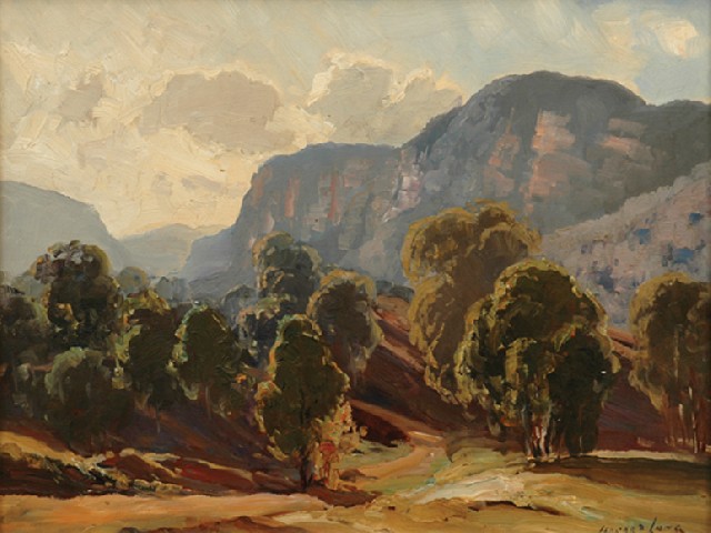
The view of the Capertee Valley from the Crown is
as awe-inspiring today as it was in 1874

Leaving this awe-inspiring scene, with some regret I proceeded on my journey and passed in due course Capertee Camp Inn, by James Shervey, 3 1/2 miles; Kangaroo Flat, Cobb's Hotel, by D. Freestone, 4 miles; Round Swamp, a nice valley in which there are cultivated paddocks and the Coach and Horses Inn, 1 3/4miles. The Running Stream is four miles beyond; the hotel on the hill top is well-known as bearing the sign “Rest and be Thankful.” Another four miles ride you get to Cherry Tree Hill where there is a toll-bar; and three-quarters of a mile beyond is the "Golden Fleece." From all these it will be seen that the weary and parched traveller need not want long for "refreshment for man and horse" on the Mudgee road. I have already noticed thirteen public-houses since leaving Wallerawang. Some of these are very old stands, and the inhabitants recall incidents of over 30 years past. At the Round Swamp for instance there is Mrs. Mansfield's "Coach and Horses." Thirty years ago she came here, and for the past 22 1/2 years has lived in the present hotel.

The town of Ilford, long known as Kean's Swamp, is two and a half miles from Cherry Tree Hill. Ilford is a very old place, situated in a most picturesque situation, at the foot of a mountain. The rocks are curiously and fantastically shaped. They rise to the height of 500 or 600 feet. There are a few nice stone buildings in the village, including a Wesleyan Church. Ilford is likely to become a more pleasing-looking place when some of the old huts and habitations are burnt to the ground, and a number of nice stone buildings now in course of completion amidst light forest scenery are opened to view. The town contains four stores : Mrs. Phelps, (post office), Messrs. G. Harris, Cordoroy's, and E. Turley's, and the inn is called "The Plough." There is a miserable slab building used as a public school: no other place of worship but the Wesleyan, and no court-house, though there is a police station. The branch roads turn off here for Sofala and Rylstone, 16 miles distant either way.

From Ilford I rode to Cunningham's Creek, a few miles beyond the town, and put up at Sid. Brown's hotel, where the accommodation is good. The following morning I had an early start. The distance to Mudgee is 33 miles. The road winds over hilly country the greater part of the way. Shortly after leaving Cunningham's Creek I ascended a hill tolerably steep, bearing the strange name of Aaron's Pass, a place which has since become very familiar to your readers, as the spot where the Mudgee mail was robbed on the 29th of May. It is just such a place as would be chosen by bushrangers, being in a wild uninhabited part of the country. Twelve miles from Cunningham's Creek, Cudgegong was reached. Cudgegong is a small township, possessing a few good buildings in freestone, two good hotels and stores, a church, and a court house. The oldest inhabitant, Mr. William Wilkins, is the host of the principal hotel. He informed me that he built the first public-house, did the first bit of blacksmithing, and killed the first bullock in the town. He is a jovial sort of fellow, one's idea of mine host; but I understand that he is about to retire to a nice free-stone private house that he has built for himself nearer the creek.

Two miles from Cudgegong I passed a place called Tarnabutta, Masters's comfortable homestead and farm. Four miles beyond, I arrived at Stony Pinch, where Baylis's farms are situated in a romantic position, and nearly surrounded by high mountains. |  

Half-a-mile beyond Baylis's, is the Stony Pinch toll-bar, kept by Masters. This is the third toll-bar that I passed through since I left Wallerawang. A few other farms were passed, and I reached Pauling's Apple Tree Flat Inn, 10 miles from Mudgee. After resting here a short time, I pushed on and reached Mudgee at sun-set, and put up at the Belmore, where I remained for a few days.

The distance from Wallerawang is variously estimated at from 70 to 75 miles. There are 21 public-houses on the way-side, but as the road is now far different to what it was in the good old days, when, for the whole distance it was boggy, and next to unpassable. I suppose that the publicans find their profits somewhat diminished.

It is not my intention to say much about Mudgee this time, as it has been so often and well-described pictorially and otherwise in these columns. I might state, however, that the town has not gone back of late years, and that there seems to be more substantial prosperity in it than ever. Notwithstanding private jealousies, party feelings, &c., the Municipal Council has done much to improve the streets, and make the town attractive. What I should regard as a drawback is the want of concentration. Mudgee is too much scattered to be comfortable for business men; and there are numerous gaps that might be well filled up with respectable buildings, or else fenced and planted with trees. And a good fire is wanted to clear off some unsightly buildings standing insultingly close to other buildings that would do credit to any city in the world. Mudgee from her position will always be enabled to hold her own. In the district there is as wealthy and enterprising a class of pastoral princes as any in the Australian colonies; and in the town there are good colonists, men whose progressive views, and belief in the destinies of Mudgee, will cause them never to allow the interests of the place to suffer for want of attention.

This article was first printed on page 28 of the 27th June 1874 issue of the Australian Town and Country Journal, a paper published in Sydney between 1870-1907.


Related Posts Plugin for WordPress, Blogger...